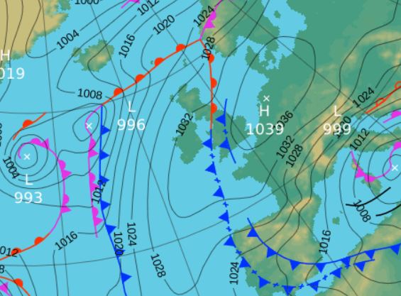
 1200 Hrs 17th - the frontal system stuck within the high pressure that gave permanently dull weather
A relatively dry month and slightly warmer than average - however, like December, a quiet month.
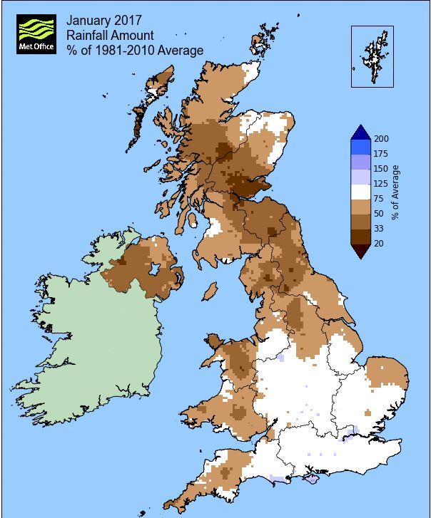
High pressure was dominant during January, albeit we often sat on the fringes of such systems as opposed to it being directly overhead, but it was the main influence on our weather during the month and hence the reason why it was so uneventful and that much drier than average.
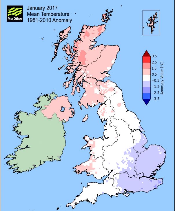
Whilst the month was marginally warmer than average we still had an average number of frosts, albeit apart from a brief spell during the 12-13th, there was a distinct lack of anything wintry. With high pressure dominant, rainfall was very much of the 'bits 'n' pieces' variety with no particularly wet days, apart from the 31st, yet especially towards the end of the month drizzle became fairly regular.
MSLP of 1020.5 Mb was +8.4 Mb above the local average for January and the highest monthly mean for January yet recorded at this site. Low pressure was mainly limited to the 9-15th and then again at the very end of the month.
Overall a mean minimum of 0.81°c and a mean maximum of 6.51°c saw the temperature 0.3°c above the 1981-2010 average and it was the coldest January since 2015 (the 4th warmest of the 9 now recorded). The highest maximum temperature recorded was 11.3°c (10th), the lowest minimum -5.2°c (27th).
Rainfall of 61.7 mm (Crosby Ravensworth School 63.7 mm - CastleHowe Scar 74.2 mm) made it the driest January since 2010 (the 2nd driest of the 10 recorded) and was 38.3% of average for 2008-16. Locally, rainfall percentages were typically below 50% of normal.
At the Met' Office site at Newton Rigg, 42.4 mm (41.8%) made it the driest January since 2010 and in a series back to 1900 there have been 16 drier and 101 wetter. In a series back to 1952 a mean temperature of 3.55°c is the coldest since 2013 with 38 having been colder, 26 warmer and 1 having the same mean temperature.
Figures from the Environment Agencyĺs rainfall sites were, (figure in brackets being the monthly average for 1961-90) ĹData kindly provided by the Hydrometry and Telemetry team of the Environment Agency (Penrith)ĺ:
Kirkby Thore 57.4 mm (70.1 mm)
Brothers Water 107.65 mm (277 mm) and
166.4 mm at Seathwaite Farm (Borrowdale - 372 mm [average for 1981-2010])
1st - 8th The month opened with the UK on the eastern fringes of high pressure (HP) centred over the Atlantic. This resulted in a run of cool but dry days and with a reasonable amount of sunshine, the 2nd especially, which was fairly glorious and without a cloud in the sky.
A cold front moved N-S during the 4th and introduced much colder air behind it and a nominal N'ly flow and subsequently the 5th whilst seeing plenty of sun, was cold. The HP was dominant over the UK and in calm winds and clear skies the temperature tumbled to -5.0°c (23.0°f) and as this was the temperature at 0900 hrs it would also by default become the minimum temperature for the 6th as well.
A frontal system crossed the UK during the 6th bringing a spell of drizzle and overcast skies, before HP in Biscay tried to reassert itself. However, with the amount of cloud trapped within the HP, it was both milder and duller and then a weak front over the UK during the 7th brought misty conditions. The HP became more dominant on the 8th and the day saw some brighter moments.
9th - 11th Low Pressure (LP) in the Atlantic tracking north of Scotland then pushed cold fronts over the UK giving rain overnight 8-9th which cleared mid morning, becoming showery. The 10th was generally quiet, albeit at 11.3°c (52.3°f), the month's warmest day, before LP north of Scotland on the 11th brought a very strong W'ly flow and which would be a day of blustery showers with a maximum wind gust of 51 Mph.
12th - 14th It turned colder from the 12th as the brisk W'ly veered NW'ly as air of Arctic origins plunged south. After those milder days, frosts now returned and day-time temperatures fell to 2.9°c on the 12th.
As fronts moved south during the 12th bringing that colder air, early sleet showers turned to snow and a 45 minute spell of heavy snow in the afternoon gave a cover that would last through to the 13th, with the help of further showers. The 13th started with a 2cm cover of snow that soon started to melt, but the day itself remained cold in a bitter wind.
The 14th became a transitional day as HP in the Atlantic moved NE and a frontal system would arrive in the late evening bringing a period of rain.
15th Those fronts that arrived late evening 14th shunted the colder air away and brought that spell of rain overnight into the 15th, giving 14.8 mm of rain (credited back to the 14th) with a further 6.3 mm on the 15th.
16th - 27th HP would then take control and dominate our weather almost to the month's end.
The HP was centred in the Atlantic to our SW but a frontal system that was strung out from LP in the Mediterranean back through Spain, the UK and north to the Arctic, would ensure that whilst it was basically dry, it was cloudy, mild and dull through to the 20th.
It was uninspiring, often murky and with a narrow diurnal range of temperatures, a true anti-cyclonic gloom.
1200 Hrs 17th - the frontal system stuck within the high pressure that gave permanently dull weather
On the 21st that front finally showed signs of movement and ventured north. We were still within the area of HP and subsequently with clearer skies, we finally got to see some sun. Those clearer skies also allowed for the temperature to dip at night and the 21st-24th all saw a slight air frost.
Temperatures dipped by day as well and the 22nd was quite bitter, only attaining 2.8°c, a month's low. However, come the 24th the HP was now retreating slightly east, allowing fronts in the Atlantic to get as far as Eire and subsequently it was another dreary day with drizzle.
But the HP just about hung on and it wouldn't be until the 27-28th that it finally gave way. This allowed for a few more frosts as the clouds broke sufficiently to give some clear skies and -5.2°c (22.6°f) on the 27th would be a month's lowest temperature and this followed a quite bitter, but sunny day on the 26th.
28th - 31st Those Atlantic fronts finally managed to push east in the early hours of the 28th, but which resulted in only giving a small amount of rain. Whilst LP was now taking control, we sat in a fairly slack flow 29-30th and had a little brightness, but the month would end on a wet note.
The 31st saw a frontal system associated to LP SW of Iceland push across the UK and bring with it a wet day. The rain lasted all day and with 17.4 mm it became the month's wettest day.
Rainfall totalled 61.7 mm for the month, with rain recorded on 18 days of which 11 were 'Wet days' (1.0mm +).
The Mean Temperature for the month was 3.66°c -- The Mean Max' was 6.51°c -- The Mean Min' 0.81°c.
We had 15 Air Frosts in the month (year 15) -- Grass frosts totalled 19 (year 19).
The 1 foot soil temp ranged from a low of 3.2°c on the 28th to a high of 6.2°c on the 1st -- with a monthly mean of 4.8°c
The 1 meter soil temp ranged from a low of 6.0°c on the 29th - 31st to a high of 7.1°c on the 1st - 3rd -- with a monthly mean of 6.6°c
COMPARISONS:-
* January 2017 rainfall was 38.3% of the January average for 2008 - 2016
* January 2017 was 0.55°c warmer than the January average for 2009 - 2016 and 0.35°c warmer than the local long term average 1981-2010
JANUARY 2010
FEBRUARY 2010
MARCH 2010
APRIL 2010
MAY 2010
JUNE 2010
JULY 2010
AUGUST 2010
SEPTEMBER 2010
OCTOBER 2010
NOVEMBER 2010
DECEMBER 2010
JANUARY 2011
FEBRUARY 2011
MARCH 2011
APRIL 2011
MAY 2011
JUNE 2011
JULY 2011
AUGUST 2011
SEPTEMBER 2011
OCTOBER 2011
NOVEMBER 2011
DECEMBER 2011
JANUARY 2012
FEBRUARY 2012
MARCH 2012
APRIL 2012
MAY 2012
JUNE 2012
JULY 2012
AUGUST 2012
SEPTEMBER 2012
OCTOBER 2012
NOVEMBER 2012
DECEMBER 2012
SUMMER 2012
REVIEW OF 2012
JANUARY 2013
FEBRUARY 2013
MARCH 2013
APRIL 2013
MAY 2013
JUNE 2013
JULY 2013
AUGUST 2013
SEPTEMBER 2013
OCTOBER 2013
NOVEMBER 2013
DECEMBER 2013
REVIEW OF 2013
JANUARY 2014
FEBRUARY 2014
MARCH 2014
APRIL 2014
MAY 2014
JUNE 2014
JULY 2014
AUGUST 2014
SEPTEMBER 2014
OCTOBER 2014
NOVEMBER 2014
DECEMBER 2014
WINTER 2014
REVIEW OF 2014
JANUARY 2015
FEBRUARY 2015
MARCH 2015
APRIL 2015
MAY 2015
JUNE 2015
JULY 2015
AUGUST 2015
SEPTEMBER 2015
OCTOBER 2015
NOVEMBER 2015
DECEMBER 2015
REVIEW OF 2015
JANUARY 2016
FEBRUARY 2016
MARCH 2016
APRIL 2016
MAY 2016
JUNE 2016
JULY 2016
AUGUST 2016
SEPTEMBER 2016
OCTOBER 2016
NOVEMBER 2016
DECEMBER 2016
REVIEW OF 2016
OTHER ARTICLES
The Oldest Inhabitant
An Inch Of Scotch Mist
© Darren Rogers 2010-16
Want to comment on this site? email